
(Click on map above for a printable version)
Approximately 110 miles
This scenic route follows two-lane highways except for 7 miles, where the only option is to use Interstate 10. Along this loop you will have the opportunity to visit Fort Lancaster State Historic Site, cross the Pecos River twice, have your picture made with Dinny the Dinosaur in Alley-Oop Park, stop to rest at picnic areas with amazing views and surround yourself in the expanse of rural west Texas.

Driving Directions:
Begin your drive at Ozona’s Historic Town Square.
Drive west on Old Highway 290 (Loop 466), known locally as 11th or Sheffield Road.
The highway designation will become Ranch Road 2398 as you pass the west entrance to Interstate 10 approximately 2 miles west of Ozona. For a more scenic drive, do not access the Interstate. Stay on Ranch Road 2398.
Continue west on Ranch Road 2398. You will pass another Ranch Road 2083 with entrance to Interstate 10 in approximately 2 miles. This is also known as Pandale Road. Again, do not access the Interstate, but stay on Ranch Road 2398 for the more scenic drive.
Continue west on Ranch Road 2398 for another 12 miles.
Some of the landmarks you will pass in this section are
8 miles – Clayton & Henderson Ranch on left
9 miles – County Road 301 and 303 on right
11 miles – Howard Draw
At County Road 405 just west of Howard Draw, turn left.
Note: You may be tempted to continue westward on the two-lane road. If you do so, you will find the road comes to an end at a ranch entrance with no legal access to the interstate, which will require you to return to County Road 405.
Continue ½ mile and then turn west (right) to access Interstate 10. You should enter at about mile marker 350. The speed limit is 80 MPH.
Continue west on I-10 for about about 6 miles. You will pass a parking area on the right just after you enter the Interstate if you need a place to stop and stretch your legs. There are no restroom facilities at this stop.
Take Exit 343 on your right and turn south (left) on State Highway 290. This is clearly marked as the exit for Fort Lancaster State Historic Site. The speed limit for this road is 75 MPH.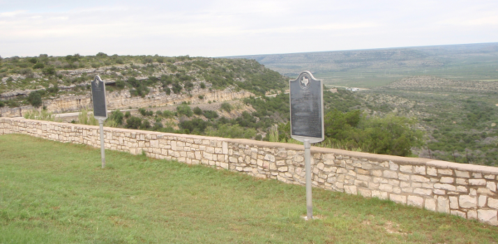 Continue south for 9 miles. There is an observation point on the left as you begin to drop off the “high country” into the Pecos River Valley.
Stop at the scenic observation point and picnic area on the left for photos of the Pecos River Valley. Be sure to take a moment to read the historical markers for Howard’s Well, the Chihuahua Trail & Escondido Water Hole as well as the Old Government Road.
Return to SH290 and turn southward (left). Continue down Lancaster Hill for 2 miles.
Originally part of the Old Spanish Trail, this winding road was constructed in the 1920s and the stone ramparts were added with New Deal funds in the 1930s. It remained the main highway until 1983 when the last Texas section of Interstate 10 was completed, bypassing the area to the north and shortening the route.
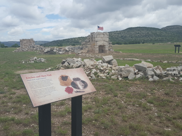
At the bottom of Lancaster Hill, you will see a sign announcing the Fort Lancaster State Historic Site. This is an excellent example of a Texas Frontier Fort with an expanded and updated Visitor Center. You will find restrooms, exhibits and a gift shop at the fort. For more information, go to visitfortlancaster.com . You will also pass County Road 411 on the left just before you reach the Fort Lancaster entrance.
 Turn right and enter the Fort Lancaster State Historic Site.
Just a few interesting facts:
If you look up toward the bluffs east of the fort, wagon ruts left by the early travelers are still visible from the parade grounds. There is an excellent marker showing the exact path of the road as you look eastward.
Established on August 20, 1865, the fort was charged with the defense of settlements and protection of early travelers through West Texas.
Two shipments totaling 74 camels passed through the fort in 1855 as part of a military experiment using them as transportation in the arid region.
Confederate soldiers briefly controlled the fort during the early part of the Civil War.
Fort Lancaster was the only frontier fort that had a battle with Native Americans on the fort grounds.
Stretch your legs and take some time to explore the Visitor Center and exhibits. Have a picnic and take a restroom break.
Optional: Retrace route to return to Ozona.
To continue the loop, when leaving Fort Lancaster State Historic Site, turn right onto SH 290.
You will cross Live Oak Draw Bridge 1 mile west of the fort entrance.
Live Oak Draw was the primary water source for the fort and still carries water during heavy rains.
Continue west for 5 miles to the historic metal truss bridge over the Pecos River (built in 1932)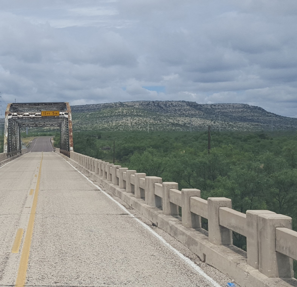
There is a pull over area on the west side of the bridge where you can stop for pictures, but be careful to watch for traffic because this road is still very active!
Please don’t try to cross a fence to get another view. This area is privately owned and trespassing is frowned upon.
Continue west on SH 290 for 4 miles to the quaint town of Sheffield.
There are no fuel stations or restaurants that are open on a regular basis.
At the intersection of SH 290 and SH 349, notice the original hotel sign with “OST Courts” on the right. Stop for a photo of one of the few remaining reminders that this was once a welcome stop on the Old Spanish Trail (OST) Highway completed in the 1920’s. The OST was one of the first continuous east-west highway routes spanning the United States.
Continue west on SH 290 for 5 miles to I-10. At the intersection of State Highway 349, turn north (right).
Cross over I-10 and continue north on SH 349 for 13 miles to another quiet town: Iraan.
3 miles north of the Interstate you will pass the Holmes Ranch entrances on the left, and there are several large buildings on the right side of the highway.
Note: For the young at heart, Iraan has an Alley Oop Fantasy Land Park, located about 5 blocks west (left) on Alley Oop Lane. It includes a museum dedicated to V.T. Hamlin, the creator of the famous cartoon strip. It’s always a good idea to call ahead for current hours of museum operation. More information is also available at iraantx.com/tourism
You can purchase gas and food in Iraan. There are several restaurants and a grocery store as well as convenience stations.
“Iraan” is a combination of the names of Ira and Ann Yates, owners of the local ranch where oil was discovered in the 1920’s.
Turn east (right) on US 190 and continue for approximately 5 miles.
Some of the landmarks you will pass in this section are
1 mile – You will cross the Pecos River bridge and return to Crockett County.
3 miles – Thompson Ranch entrance on left.
On the left (north) side of the highway as you climb out of the Pecos River Canyon there is a small picnic area. Turn left into the entrance and proceed to the overlook where you will find a stunning view of the Pecos River Canyon to the west.
As you prepare to leave the picnic area and return to US 190, be aware of fast moving traffic traveling down the long incline. Turn east (left) back onto US 190 and continue east 23 miles to the junction with SH 137.
Some of the landmarks you will pass in this section are
1 mile – a wide area at the top of the hill where you can stop for another photo or two. Please be aware of traffic.
2 miles – Hershey Ranch on left
8 miles – County Road 305
21 miles – County Road 207 and the Shannon Ranch entrance
There is a historical marker about Crockett County's first producing oil well to the right at the junction of US 190 and SH 137.

Continue east on US 190 for 2 miles.
Follow SH 137 when it splits from US 190 toward the south (right).
In 2 miles you will pass TX Ranch Road 1964 on the right. Stay on SH 137.
Continue east for another 15 miles on SH 137.
Turn south(right) on SH 163 and continue 2 miles to return to Ozona.
Enjoy one of Ozona’s many fine restaurants and grab a great night’s sleep before trying another of Ozona’s itineraries!
Thinking about visiting the area?
Learn more about Ozona and Crockett County
when you visit our Tourist Information page.
Return to our Travel Itinerary Page