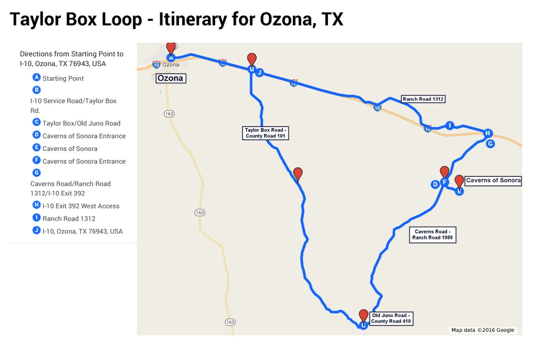
(Click on map above for a printable version)
Approximately 73 miles
Note: Once you leave Ozona, the only other available fuel stop will be 6 miles east of Ozona.
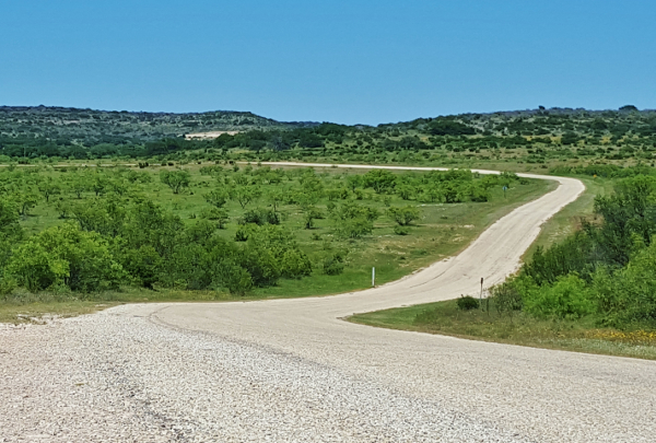
Be sure to pay attention to all warning signs as this loop travels along roads which are used for various ranching and oilfield activities. In some places, sharp and blind curves will be encountered. You will be crossing cattle guards along this route, which means that ranch stock may occasionally be on the roadway. Please drive with courtesy and caution.
Temperatures for this loop can reach above 100 degrees in the afternoon for much of the summer, so this route is recommended for spring and fall. Be sure to check the weather forecasts before you travel because Texas weather can change quickly!
Reminders:
There are no fuel stations or convenience stores along this route until you are 6 miles east of Ozona on the return leg of your journey, so make sure you have a full tank of gas, some fresh drinking water and snacks.
Be aware of the weather conditions. This area is prone to flash flooding.
If you find yourself in a flash flood, do not drive into water. You and your motorcycle can easily be washed downstream in the swift current. Don't Drown, Turn Around! Head for higher ground.
If caught between flooded crossings, remember that flash floods pass quickly. Be patient, the waters will recede soon, usually within an hour or two.
This is a remote and primitive area. The nearest emergency services will be miles away.
Watch out for snakes, insects and other critters that might spoil your fun.
Take plenty of fresh drinking water and use your sunscreen.
There is no reliable cell phone service for much of this loop.
Please remember that 97% of Texas is private property and you will be trespassing if you leave the roadway.
Driving Directions:
Begin at Ozona’s Historic Town Square.
Drive east on Loop 466, known locally as Old Highway 290, where you will pass through a beautiful tree-lined avenue of mansions. The section is also called “Silk Stocking Row”. Early ranching families built town homes for children and their mothers to live while attending school. As many families became rich during the oil boom of the 1920s, their homes became increasingly elaborate. These homes stand as a vivid reminder of the time when Ozona had more millionaires per capita than any place in the world.
Continue east on Loop 466 for approximately 2 miles. The road will join the north service road for Interstate 10.
Continue on the service road for another 4.5 miles. Be aware that this road has two-way traffic as it is the only access road for this section of I-10.
***(Note: There will be no available fuel for the next 60 miles.)***
Turn south (right) on County Road 101, also known as Taylor Box Road.
Cross over I-10 and continue driving along Taylor Box Road for approximately 25.4 miles. Along the way the designation for the road will also be County Road 411.
Some of the landmarks you will encounter along the way are:
1 mile – Davidson Ranch
3 miles – Flying W Ranch
5 miles – Perry Ranch
6 miles – McMullen Ranch
10 miles – Henderson Ranch
11 miles – Branyon Ranch
11 miles – Read Ranch
15 miles – Yucca Lily Ranch – Beyond this point, you will be crossing several cattle guards
18 miles – Seahorn Ranch
20 miles – Moore Ranch
21 miles – The pavement narrows for about one mile.
22 miles – Friend Ranch
23 miles – Dorothy Friend Ranch
Taylor Box Road will join the Old Juno Highway, also designated County Road 410, and will begin to loop northward.
Continue along the Old Juno Highway for approximately 9.7 miles.
Landmarks along this section include:
3 miles – Weitz Ranch –The sign is facing northwest as private road intersects from the east.
5 miles – Cedar Bluff Ranch on left
The Old Juno Highway will come to a T-intersection with Glasscock Road.
At this point, you have an opportunity to turn west (left) toward Ozona on Sutton County Road (SCR) 110, also known as Glasscock Road. If you choose to do so, you will be traveling approximately 14 miles back to Interstate 10. This will shorten the loop by about 7 miles and you will not pass the Caverns of Sonora. SCR 110 will wind northward until it passes underneath I-10 and intersects with Ranch Road 1312. Turn west (left) on RR 1312. In approximately 2 miles, you will have access to I-10. If you choose to remain on RR 1312, you will parallel the interstate for about 16 miles, ending back at Ozona’s Historic Town Square. Fuel is available 6 miles east of Ozona.
Turn right at the intersection where Old Juno Road joins Sutton County Road 410 and eventually becomes Ranch Road 1989, also designated the Caverns Road. Across from the intersection, you will see a corral and stock pens for the Whitehead Ranch. Very soon after turning you will cross a cattle guard and the pavement will widen. The speed limit then be 70 MPH.
Continue on Ranch Road 1989 for about 5.8 miles. The entrance for the Caverns of Sonora, one of Ozona’s many local attractions will be on your right (the east side) of the road. This entrance is very easy to miss because it joins at an angle and the sign faces to the north but does not face toward the south. Pay attention or you will drive right past it.
At this point you might want to visit caverns. If so, turn right on Private Road 4468.
Continue east on the Private Road 4468 for about 1.5 miles to the caverns headquarters.
Enjoy a tour of the beautiful caverns filled with a myriad of spectacular formations. Guided tours are available from 9:00 a.m. to 5:00 p.m from the Tuesday after Labor Day until the end of February. From March 1st to Labor Day the hours are 8:00 a.m. to 6:00 p.m. Tickets must be purchased at least 30 minutes prior to the departure time. Visit www.cavernsofsonora.com for more information.
Return to Ranch Road 1989, turn northward (right).
Continue on Ranch Road 1989 for 6 miles to Interstate 10.
Cross over Interstate 10 to Ranch Road 1312, the north service road.
Turn west (left) on Ranch Road 1312.
At this point, there are two options to return to Ozona.
***There is available fuel 6 miles east of Ozona, if needed.***
- Option 1: Continue on two-lane roads.
Continue west on Ranch Road 1312 for approximately 12.5 miles. At this point you will cross back into Crockett County.
Note: The small building on the east side of the county line at one time was Ozona’s nearest liquor store where local residents shopped before the county residents voted to no longer be a “dry” county on June 3, 1988. Up until that time, the residents could not purchase alcohol for off-premises consumption in Crockett County. (Reference Texas Alcoholic Beverage Commission -458)
Continue west on Ranch Road 1312 for approximately 17 miles back to Ozona’s Historic Town Square.
- Option 2: Take entrance to I-10 for the fastest route.
Turn west, or left, onto the entrance ramp for Interstate 10.
Continue west on Interstate 10 for 28 miles to Exit 365.
Enjoy one of Ozona’s many fine restaurants and grab a great night’s sleep before trying another of Ozona’s itineraries!